Showing posts with label Orange River. Show all posts

Saturday, 10 August 2024

South Africa: Orange River at Upington water levels and flood

Orange River water level in 2022 & 2023 - Northern Cape, South Africa.
Mention Upington and the mind conjures up visions of a desolate unbaked southern Kalahari desert town where man's existence is a daily struggle. But how wrong can one be.

Through this harsh landscape that surrounds Upington runs a glittering green ribbon - the fertile Orange River valley which brings life-giving water from the distant highlands of Lesotho to the town.

Location

The town is centrally located on the Namaqua Route between Johannesburg, Cape Town and Namibia. As such road kilometer distances between Upington & the following town are:
Johannesburg 804, Cape town 894, Windhoek 973, Augrabies Falls National Park 120, Kgalagadi Transfrontier National Park 268, Kimberley 411, Springbok 374, Buchuberg Dam 120 Groblershoop 121, Keimoes 40, Kakamas 81, Pofadder 206, Kenhardt 130, Rietfontein 219.

POPULATION

Approximately 60 000 people live in Upington.

HISTORY

A Hottentot chieftain Klaas Lucas, realized the value of being able to read and write. He also knew that the missionaries could help his people to acquire these skills, so in 1870 he appealed for the establishment of a mission station at Olyfenhoutsdrift (Ford at the olivewood trees). The Reverend Christiaan was sent up from Cape town. Permission to establish the Olyfenhoudsdrift Mission was secured from Klaas Pofadder who claimed ownership of the area.

Consequently, building work began when foundations were laid in 1873. Pioneer settlers such as Japie Lutz and the Reverend Christiaan were quick to realize the irrigation possibilities along the Orange. They hand dug the first irrigation canals in 1880 and some of them are still in use today. Since then Upington grew rapidly and became the commercial, agricultural and educational center of the Gordonia district. The latter was named after sir Gordon Sprigg, a former prime minister of the Cape Colony.

ATTRACTIONS

The Mighty Kalahari
Discover the unspoilt beauty of this less travelled region. Hunting, hiking and sightseeing are a few of the many activities available to keep you busy.

Kalahari Gemsbok National Park
Game viewing at its best

SA Dried Fruit Co-operative

Situated on the road to Groblershoop. More than ten percent of South Africa's vineyards or 23,5 million vines are cultivated along the lower Orange River. Products are distributed to the United Kingdom, Germany, Japan, Canada, Switzerland, the Scandinavian Countries and Argentina. The factory covers an area of more than 2 ha and processes and packs all dried sultanas in the country.

Kalahari Oranje Museum

Built by the Reverend Schroder in 1875 as a church and mission station. Domestic items dating from that era and articles relating to the history of Upington and the lower Orange River can be seen here. The museum is home to the life-sized monument of the donkey, sculptured in bronze by Hennie Potgieter.
It symbolizes the unselfish contribution made by the donkey in developing the Lower Orange River Valley during the pioneer days.

Oranje Rivier Co-operative Wine Cellars

Situated in the industrial area. This five cellar co-operative is the second largest in the world. It presents the visitor with a unique range of natural and fortified wines. Wine tasting & tours are offered.

Augrabies Waterfall

Named by the Khoi people, Augrabies, meaning "Place of great Noise". It is truly a spectacular sight to see the Orange River cascading 60m down in a mighty waterfall.

Skaapland Butchery Franchise

International specialists in the meat industry recognise Skaapland Butchery as one of the most modern butcheries in the world and equals German Technological standards. It is the first registered butchery franchise in South Africa and worth a visit !

Spitskop Nature Reserve

Only 13 km from Upington, it offers wonderful game viewing and bird watching.

ECONOMY

Upington's economy relies heavily on agriculture, tourism and the service industry. There is also a lively informal sector present in the town. A number of companies like the Oranje Co-operative, Karakul & Livestock Co-operative (KLK) and Oranje Rivier Co-op Wine cellars have their head offices in Upington.
Purchase photo/4K video: portfolio1 portfolio2
Aerial photo/video service/inquiries: info@traveltonamibia.com
Telegram: ExploringNamibia

Tuesday, 4 June 2024

South Africa: Bruydegom, Israel, Theresina, Juno, Tandeka & Sail Fisher shipwrecks

SAHRA Maritime and Underwater Cultural Heritage

April 9:

“This day in our shipwreck and aeronautical wreck history”

Eduard Bohlen shipwreck in Namibia

1674: Bruydegom, this wooden sailing vessel struck a rock between Meeu Island and Schaapen Island in the Langebaan lagoon in the Western Cape. It then drifted into the shallower parts of the lagoon, finally foundering in Kraal Bay. It had a cargo of limestone and shells on board and was waiting for favourable winds to head back to Cape Town.

1847: Israel, this wooden sailing barque (a whaler) had its cables part during a north-westerly gale and it wrecked on Salt River Beach in Table Bay in the Western Cape. It had originally entered Table Bay for fresh water.

1878: Theresina, this wooden sailing vessel’s anchor cable parted during an east-north-easterly gale and it wrecked on Back Beach in Durban in KwaZulu-Natal. The crew were saved using a rocket apparatus as quicksand apparently engulfed the vessel and its cargo rapidly. The cargo included a deluxe bus. Many attempts to get it out of the wreck failed, and the ship and cargo eventually disappeared beneath the sand. However, the masts stuck out and it could still be observed at high tide. In 1913/14 the wreck was temporarily exposed, and attempts were made to get the bus out, but these were also unsuccessful. A wreck was demolished in 1936 on Back Beach and it is suspected that it may have been the Theresina.

1885: Juno, this sailing schooner foundered south of the Orange River off the west coast in the Northern Cape. A fire broke out on board late at night on the 8th and it was abandoned the morning of the 9th. It foundered shortly after. When the crew of 21 attempted to land, their boat capsized in the surf, and only four survived.

1977: Tandeka, this ferro-cement sailing yacht wrecked east of the Dassen Island Lighthouse off the west coast in the Western Cape.

1977: An outboard motor-powered dinghy (name unknown) was lost at sea with two people on board off Hout Bay in the Western Cape. 

2002: Sail Fisher, this fishing trawler, whilst returning from catching hake, ran aground on a rock and sank in House Bay on Dassen Island in the Western Cape. The crew of 10 got off safely and divers managed to pump off 400 litres of diesel fuel. The superstructure and debris were also removed so that the wreck would not pose a danger.

Purchase photo/4K video: portfolio1 portfolio2
Aerial photo/video service/inquiries: info@traveltonamibia.com
Telegram: ExploringNamibia

Sunday, 15 October 2023

Namibia: Ghost Town Where Diamond Mining Once Thrived

The Spooky Ghost Town Where Diamond Mining Once Thrived

Kolmanskop, a once-thriving diamond mining town nestled in the Namib Desert, is now a ghost town visited only by tourists who regard it as a haunted town due to its history and spooky appearance.

Its history started in 1908, when a railway worker named Zacharias Lewala stumbled upon a sparkling stone along the riverbed that turned out to be a diamond, leading to the discovery of significant diamond deposits in the area.

The discovery sparked a diamond rush, drawing fortune seekers from far and wide to establish Kolmanskop as a diamond mining center. By 1912, a town had sprung up, producing a million carats a year or 11.7 percent of the world’s total diamond production.

As diamond production grew, Namibia‘s Kolmanskop evolved from a modest settlement to a thriving town. The influx of mining companies and workers brought about rapid urbanization, industrialization, and infrastructure development.

The town was constructed primarily by German immigrant architects.

The town boasted amenities such as a hospital, school, theater, and even a tram system, which reflected its prosperous state.

The buildings, constructed primarily by German immigrant architects, featured distinct German colonial characteristics, combining elements of both German and Namibian design. This blending of styles created a remarkable aesthetic that still captivates visitors today.

The diverse population of Kolmanskop, including miners, merchants, and their families, developed a vibrant social fabric. Settlers from various backgrounds brought their customs and traditions, fostering a rich multicultural environment. Despite the harsh desert conditions, residents established recreational clubs, sports teams, and social gatherings, illuminating the unique spirit of community that permeated Kolmanskop.

Kolmanskop’s prospectors were becoming rich overnight simply picking diamonds off the desert floor, but German colonial authorities wanted greater control over the incredible riches.

According to a report in National Geographic, they cracked down, declaring a vast area of Namibia a Sperrgebiet, or restricted zone, forbidding entry to ordinary people and reserving prospecting rights for a single, Berlin-based company.

However, as diamond resources in the area were depleted, the town was gradually abandoned. The residents left behind their homes, possessions, and even some personal belongings, creating a ghostly atmosphere of a town frozen in time.

Hastening the town’s demise was the discovery in 1928 of the richest diamond-bearing deposits ever known. These were on the beach terraces 270 km south of Kolmanskop near the Orange River.

By 1956, Kolmanskop was completely abandoned. The dunes that once rolled over Lewala’s railway tracks now burst through the ghost town’s doors and porches, filling its rooms with smooth banks of sand.

In the decades following its abandonment, Kolmanskop transformed into a popular tourist attraction, drawing visitors who sought to witness the remnants of a once-prosperous town swallowed by the desert.

Visitors and paranormal enthusiasts have reported various ghostly encounters and strange occurrences in Kolmanskop. These stories include hearing disembodied voices, footsteps, and the feeling of being watched. Some claim to have seen apparitions or encountered unexplained phenomena, contributing to the town’s haunted reputation.

Kolmanskop’s isolation and the eerie silence of the desert contribute to the eerie and unsettling atmosphere, making it a prime location for ghost stories and urban legends.

Purchase photo/4K video: portfolio1 portfolio2
Aerial photo/video service/inquiries: info@traveltonamibia.com
Telegram: ExploringNamibia

Thursday, 21 September 2023

Namibia: Bo Plaas camping site temporarily closed

Bo Plaas camping site temporarily closed till November 2023

State-owned enterprise, mandated to run the tourism facilities within the country, Namibia Wildlife Resorts (NWR) announced the temporary closure of the Boplaas campsite.

The campsite is located in the /Ai-/Ais Richtersveld Transfrontier Park along the Orange River in the //Karas Region and will be closed effective 14 September.

The temporary closure is due to security and infrastructure upgrades and a three-metre fence will be erected as well as the construction of ablution facilities.

All confirmed clients will, for now, be moved to Ai-Ais Resort for the meantime as Bo Plaas campsite is expected to reopen again on 1 November 2023.

Purchase photo/4K video: portfolio1 portfolio2
Aerial photo/video service/inquiries: info@traveltonamibia.com
Telegram: ExploringNamibia

Monday, 28 March 2022

Namibia: aerial video of Fish River meeting Orange River | Реки Фиш и Оранжевая Намибия

#NamibiaRainyChronicles #ExtremeWeatherSouthernAfrica #FishAndOrangeRivers #HelmeringhausenRiver #DieHelmeRiver

A rainy season aerial video reports by Mr. Björn Basler: flowing rivers in Helmeringhausen area: Die Helme River and Fish River flowing into Orange River in March 2022.

Floods in Windhoek and Namibia, January 2021:

https://youtu.be/CTKSLfBjFVU

Keetmanshoop:

http://www.namibweb.com/keetmanshoop.htm

Historical floods in Namibia with photos:

http://www.namibweb.com/floods-namibia.htm

According to the latest estimates 2021-2022 rainy season is one of the best in Namibia's recorded history although some parts of the country experienced damaged, blocked and closed roads, flooded houses, burst dams and washed away walls. Flash flooding has been reported as well as severe flooding in southern regions of Namibia. NamWater reported that most dams in Namibia are close to 100% full.

YouTube video:


Björn Basler:

https://www.facebook.com/bjorn.basler.7

1. "Meeting-point" (GPS: -28.093096, 17.1740684): The Fish River meeting the Orange River on 15 March 2022. Fish River still feeding the Orange River with substantial amount of water.

2. Helmeringhausen Glamping Adventure Camp
Karas Region

COOPERATION:

1. Send your video to namhren@gmail.com
2. Watch it on our compilation
3. Get links and views to your channel

YouTube channel Exploring Namibia TV publishes four video a week: on Tuesdays, Thursdays, Saturdays and Sundays. Themes range from travelling in Africa to exploring Europe and Russia. No annoying endless begging "hit/smash that bell" and "don't forget to sub" here.

© Exploring Namibia TV

Facebook:

NAMIBIA:
https://www.facebook.com/groups/namibia.namibia

✩F A C E B O O K | ФБ ►https://www.facebook.com/ExploringNamibiaTV
✩INSTAGRAM | ИНСТА ►https://www.instagram.com/exploringnamibia
✩V K EN TV | ГРУППА ВК ►https://bit.ly/2I3ws4P
✩T W I T T E R | ТВИТТЕР ►http://twitter.com/TravelToNamibia
✩PURCHASE VIDEO P5 | ПОРТФОЛИО P5 ►https://bit.ly/2Vvbb6L
✩W E B S I T E | САЙТ ►http://www.traveltonamibia.com
✩C O N T A C T | КОНТАКТЫ ►info@traveltonamibia.com
✩W H A T S U P T E X T | ВОТСАП ТЕКСТ: +264 816 654893

www.traveltonamibia.com
YouTube: Exploring Namibia TV
Purchase photo/4K video: portfolio1 portfolio2
Aerial photo/video service/inquiries: info@traveltonamibia.com
Telegram: ExploringNamibia

Monday, 19 July 2021

Namibia - Sandfontein Lodge & Nature Reserve | Сэндфонтейн Намибия

THE DREAM STARTS HERE

Far from the crowd, in a wild and isolated corner of southern Namibia, you will find a uniquely private hideaway. The Sandfontein Lodge & Nature Reserve is a magical destination for nature lovers and adventure seekers alike. Home to arid plains, dry riverbeds and the mighty Orange River, Sandfontein has just five eco-conscious bungalows.  It’s a soul-stirring place where guests have all they need to relax and reconnect with nature.

Our Philosophy:

• Silence, stars, seclusion.

• Find yourself. In the middle of nowhere.

• The ultimate luxury is real space, solitude and tranquility – not easily found.

• One of Africa’s largest private nature reserves at 200,000 acres (81,000 hectares), 25 km of Orange River frontage and a maximum of 10 guests (1 guest per 81 square km!).

• Reconnect with nature, relish the silence, sleep under the stars.

• No timetables.  You decide the what, where and when.

• Relive the battlefields of Sandfontein (1914) and Norechab (1906).

• Rock-amour. Boulder fields. A geological paradise.

• Canoe. Hike. Fish. Bird-watch. Track on foot. World-class star gazing. Scenic drives.

The Lodge

a. 4 chalets + 1 suite = 5 rooms in total sleeping two each – maximum of 10 guests

b. 20 metre lap pool

c. Children are welcome

d. To preserve its magical silence, the lodge operates entirely on solar energy (therefore NO air-conditioning!)

e. The kitchen is supplied with delicious fresh produce from the lodge’s dedicated organic vegetable garden

THE GREAT OUTDOORS

It’s easy to fall in love with the peaceful bungalows at Sandfontein, and with the cool inviting 20 metre lap-pool.

But as soon as the morning sun throws light over the rippling Namibian mountains, birds begin to sing, butterflies flutter into life, and the reserve’s big game animals gradually start to awaken, giving visitors a very good reason to get out and explore one of Africa’s largest privately owned nature reserves.

WHAT TO DO…?

No timetables, no constraints. You decide what, where and when.

1. Scenic and sundowner drives. Animals outnumber visitors at Sandfontein by more than 400 to one. But the reserve is bigger than the island of Singapore and the animals are free to roam across the wild terrain. Discover the beauty of Sandfontein on a scenic drive and sighting one of the animals on the huge reserve is a bonus!

2. Hiking and nature trails.

3. Canoeing, fishing and/or bird-watching on the Orange River.

4. Photography: earthly ecstasy for photographers – the dramatic landscape, fauna and flora, and ever-changing light devours both film and memory.

5. World-class star-gazing: Because Sandfontein is remotely located in the second least densely populated country on Earth, the night sky and star-gazing is, quite literally, a staggering experience for those unaccustomed to it.  In fact, it is so remarkable that scientific teams have made use of the lodge to observe and measure the specific events unfolding in the universe.

6. Rock-amour: For lovers of geology, Sandfontein is a playground waiting to be discovered.  The scale of the landscape dwarfs you as you wander amongst giant boulder fields. Diverse formations and rock types, including deposits of beryl, amethyst and tantalite, make Sandfontein something of a geological oddity.

7. Air safaris and flights over the Fish River Canyon (by prior arrangement, charges apply).

THE ANIMALS

Sandfontein has the privilege of being home to more than 3,000 animals including but not limited to aardvark, baboon, eland, giraffe, jackal, klipspringer, kudu, leopard, oryx (gemsbok), ostrich, red hartebeest, springbok and zebra.

While vehicle-based safaris can be undertaken day or night, Sandfontein is very large and therefore the animal density is relatively low.

THE BATTLE OF SANDFONTEIN

As the site of the legendary 1914 Battle of Sandfontein, the reserve is rich in historical significance. The combined British and South African forces, more than 2,500 in number, with some 4,300 support animals, were desperate for water.

They were ambushed and ultimately defeated by the German colonial troops, comprised of four machine-gun units, ten artillery units, and 1,700 riflemen. At the end of the battle, 50 enemy were dead, 100 injured and some 200 prisoners taken. The clash is the only battle during World War One where the South African forces suffered a resounding defeat at the hands of the lesser German troops.

Today the landscape is a living museum sprinkled with mini ramparts, shells and food tins - clues as to how the troops tried to survive in this dramatic landscape. Two German war graves lie on Sandfontein – one within walking distance of the lodge – and are still maintained by the German government.

THE BATTLE OF NORECHAB

Another living museum, also part of Sandfontein Nature Reserve, is the Battle of Norechab that took place on 14 February 1906 and was planned by the Nama (then known as the Hottentots) against the Schutztruppen.

200 Nama approached the German camp under the cover of night and they started their attack at first light.  The Schutztruppen were ready for battle within six minutes, having been joined by a neighbouring division of 30 men who had heard the gunshots.  The attack failed and the Nama were defeated.  The Germans suffered five deaths and a further seven were wounded.  As the Nama were unable to give their dead a proper burial, and because there is no written record of their account, we can only find out more information on their losses through further research.

THE AIRFIELD

& “DESERT CLASS” LOUNGE

• Sandfontein’s excellently maintained airfield is approximately 5 kilometers west of the lodge.

• GPS coordinates: S28°43’11? E18°30’38?. Length: 1,400 meters. Elevation: 2,150 feet. Runway Headings: 09/27.

• Gradient is 3% - slopes UP from east to west and therefore we recommend landing on runway 27.

• A good windsock is maintained at the threshold of runway 09. Four brick run-up pads are also provided for parking and engine-checks.

ORABO RIVER VILLAGE

OraBo, a portmanteau of “Orange” and “Bohemian” is a tiny village originally established decades ago as an Italian mission station. Located a few hundred metres from the Orange River, OraBo offers self-catering accommodation set within the Sandfontein Nature Reserve. The fishing is world-class.

There are two comfortable self-catering guest houses that can accommodate up to six guests per house. Camping is also available at designated spots for tents and motorhomes. 

The GPS coordinates are: S.28 85202 E.18 57648.

Purchase photo/4K video: portfolio1 portfolio2
Aerial photo/video service/inquiries: info@traveltonamibia.com

Wednesday, 30 October 2019

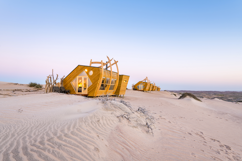
Namibia: Shipwreck Lodge in Skeleton Coast National Park | Шипрек Лодж Намибия

#Namibia #ShipwreckLodge #SkeletonCoastNationalPark #ШипрекЛодж #Намибия #Africa #Swakopmund #MoweBay #TerraceBay #CapeCross #Angola #OrangeRiver #WalvisBay

Shipwreck Lodge, Skeleton Coast National Park in Namibia

The Shipwreck Lodge is a newly opened remote accommodation establishment in Skeleton Coast Park at the wild western coast of Republic of Namibia. The unique chalets design resembles many ships' remains perished in these inhospitable waters. The Skeleton Coast Park is one of a kind in whole of Africa if not in the world, place of many maritime disasters and tragedies with inaccessible wild dunes and waterless huge tracts of the Namib Desert stretching from the Orange River in South Africa to the border with Republic of Angola.

Skeleton Coast Park entrance


Purchase photo/4K video: portfolio1 portfolio2
Aerial photo/video service/inquiries: info@traveltonamibia.com