Showing posts with label Ugab River. Show all posts

Thursday, 24 February 2022

Namibia: Flash floods have wiped out EHRA Base Camp!

19 February 2022

Elephant Human Relations Aid (EHRA)

Absolute nightmare - Flash floods have wiped out EHRA Base Camp!

We are in complete shock.

After being, initially, so elated by the recent rains, we are absolutely devastated having received nightmare news and footage from our camp team.

Base camp has essentially been wiped out by the force of water roaring down off the surrounding area - including a vehicle & trailer being actually picked up by the force of the water, dragged into the path of the river, carried 300 metres downstream, and buried up to the steering wheel in mud.

The entire valley coming from the main road transformed into a river! Can you imagine?

Thank goodness nobody is hurt!

Rachel has just left with a back up team to assess the full extent of the damage and to take provisions to the stranded team.

The Uis to Khorixas road is currently officially closed, as; parts of the road have washed away, the bridge over the Ugab has partly collapsed and more rain is expected…

…she will let us know more as soon as she gets through….

Remember the Pleasure Dome?.. The securable store containing our high value equipment is GONE and the elephant protection walls for the borehole have been destroyed. Also the elephant dam is gone.

As per the photos, the sleeping platform has been mutilated almost beyond recognition...
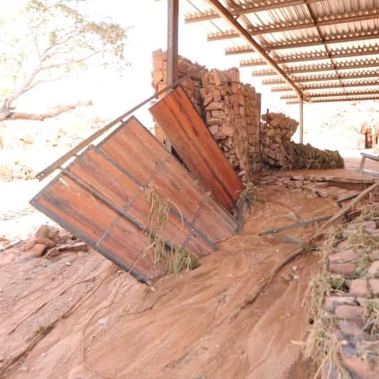
The base camp team currently have limited food & water and are sheltering on high ground in tents belonging to an adjacent camp (thank you Tracks & Trails).

We will keep you posted once we hear more news!

This is so hard to fathom... So difficult to comprehend the extent of this disaster.

Any help is always so welcome thank for all your incredible support!

Purchase photo/4K video: portfolio1 portfolio2
Aerial photo/video service/inquiries: info@traveltonamibia.com

Tuesday, 9 February 2021

Namibia: Atlantic West Coast shipwrecks: "Benguela Eagle" & "Canute" | Кораблекрушения Намибии

Namibia: West Coast shipwrecks: "Benguela Eagle" & "Canute" | Кораблекрушения у западного побережья Намибии

Facebook groups:

NAMIBIA

SKELETON COAST NATIONAL PARK

SHIPWRECKS

9. "Benguela Eagle" wreck

Date: 05.06.1973

Location: 25 km north of Ugab River

The shipwreck is located 25 km north of the Ugab River, inside the Skeleton Coast National Park. Benguela Eagle was a 78 ton fishing vessel that ran aground on 05 June 1973. According to another source of information Benguela Eagle fishing vessel was wrecked between the Uarib and Hoanib rivers in 1968 and not in 1973.

10. "Canute" wreck

Date: March 1861

Location: Ichaboe Island

No photos of these two wrecks are available.

Purchase photo/4K video: portfolio1 portfolio2
Aerial photo/video service/inquiries: info@traveltonamibia.com

Thursday, 21 January 2021

Namibia: The Vingerklip (Rock Finger) - the landmark rock in Damaraland

The Vingerklip (Rock Finger) is a tall, thin rock balanced on top of a hill. It is 35 m high and 15 m wide. It is a conglomerate monolith. Vingerklip Lodge is the nearest accommodation establishment.

Vingerklip Lodge YouTube video:


About 120 million years ago, when the super-continent of Gondwana broke up and South America drifted away from Africa, the southern African plate rose and increased the slope to the sea. The steeper slope made the Ugab River to flow faster, and it eroded more soil. For the next 100 million years the Ugab River cut deeper and deeper into the rock.
At the end of the ice age, 10 to 20 million years ago the sea level rose. The flow of the Ugab River slowed and filled the riverbed with over 100 meters of sand and rock. Two million years ago, during the northern hemisphere ice age, the sea level dropped again. Although the Ugab River once again flowed faster and cut into the previously deposited sediments the riverbed became progressively narrower.

The Ugab River was rich in dissolved carbonate. As the riverbed narrowed the carbonate glued rocks and sand into a conglomerate which was as hard as concrete.
As the riverbed continued to cut deeper and became narrower it formed terraces of decreasing heights.

Over the last 2 million years smaller rivers formed and flowed. The carbonate was washed away, leaving the hardened rock and sand in place. The Vingerklip is a part of an eroded terrace.

When looking south from the Vingerklip the different, flat terraces of the Ugab can be seen. The main terrace is the oldest and widest part of the riverbed. It is more than 160 metres above the present riverbed. A medium-aged terrace follows at 100 metres, and the youngest terrace rises only 30 metres above the modern Ugab.
Since this area does not get much rain and, the Vingerklip sits on a sound 44 meter wide base, it is unlikely to fall over in the near future as the "Finger of God" did in December 1988.

In 1970 American mountaineer Tom Choate was the first to climb the Vingerklip. His hooks can still be seen today. In 1973 the east side of the Vingerklip was conquered by free climber Udo Kleyenstuber.
Purchase photo/4K video: portfolio1 portfolio2
Aerial photo/video service/inquiries: info@traveltonamibia.com