Video, including aerial, of Cape Town's picturesque suburb with its beach and harbour, a bonus is aerial video of whale swimming in Atlantic Ocean, Western Cape, South Africa.
#HoutBayAerialVideo #CapeTownSouthAfrica #WesternCapeHarbour

Hout Bay view from Chapman's Peak
YouTube video of Hout Bay town and harbour:
Hout Bay (Afrikaans: Houtbaai or "Wood Bay") is a seaside suburb of Cape Town in the Western Cape Province of South Africa. It is situated in a valley on the Atlantic seaboard of the Cape Peninsula, twenty kilometres south of the Central Business District. The name "Hout Bay" can refer to the suburb, the bay on which it is situated or the entire valley.
The area was originally made up of two farms, which were slowly subdivided to make way for urban expansion. While still maintaining its rural atmosphere, the area of Hout Bay has more than 5,960 residences inhabited by a population of at least 17,900 people (as of 2011).
Dutch colony
When the Dutch established a colony in Table Bay in 1652, a great quantity of good timber was required for construction, shipbuilding and other purposes. There was no large forest in the immediate vicinity of the settlement, mainly because the rainfall was not high enough. It was soon apparent that the colonists would be able to fell wood they needed in the wetter valley that lay on the other side of a low pass (now Constantia Nek) between the southern end of Table Mountain and Constantiaberg. Van Riebeeck described the forest of Hout Bay as being the finest in the world. It was Van Riebeeck who gave Hout Bay its present name. In 1652 on 22 November Van Riebeeck wrote in his journal about T’ Houtbaaitjen. Since then it has been known as Hout Bay.
 |
| Hout Bay's bronze leopard |
 |
| East Fort battery |
In 1895 Walter Gurney built the first church in Hout Bay. It still stands today and is known as St Peter's the Fisherman. The first school in Hout Bay was started in this church.
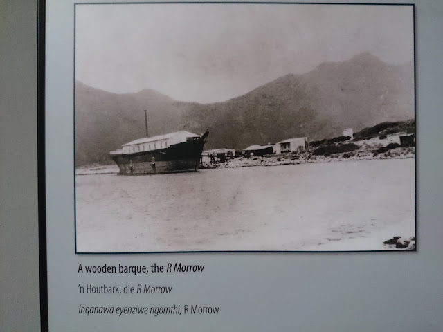
Morrow - Factory Boat
In 1904 Hout Bay's first crayfish canning factory was established in the wreck of an old sailing ship, The R Morrow that stood where the present South African Sea Products factory is today. For almost 10 years the factory operated successfully exporting canned crayfish overseas and providing work for the local inhabitants. On 31 July 1914 a leak in the acetylene gas supply caused an explosion which blew up the canning factory, killing 7 people including the owner Mr. Lucien Plessis.
Chapman's Peak
In 1922 Chapman's Peak Drive was opened to the public. It had been built by the provincial administration using convict labour. It had taken 7 years to build and had cost (R40 000).
Fishing industry
German immigrant and farmer, Jacob Trautmann, established the first fishing village here in 1867. The fishing industry expanded substantially in the 1930s when fish became a popular item on menus and improved facilities for transporting fish inland were created. The Trautmann family improved their fishing boats and built more sheds on the beach for processing the fish. They owned Trans Africa Fisheries.
YouTube channel Exploring Namibia TV publishes four video a week: on Tuesdays, Thursdays, Saturdays and Sundays. Themes range from travelling in Africa to exploring Europe and Russia.
© Exploring Namibia TV
Soundtrack:
Cold Blue
by
Astron
Facebook:
NAMIBIA:
https://www.facebook.com/groups/namibia.namibia
CAPE TOWN:
https://www.facebook.com/groups/cape.town.group
EQUIPMENT | ОБОРУДОВАНИЕ:
AERIAL: DJI PHANTOM 3 PRO | DJI MAVIC PRO
PHONES: IPHONE XR | XIAOMI REDMI NOTE
VIDEO CAMERAS: SONY HDR-CX360E | PANASONIC HC-X1
✩F A C E B O O K | ФБ ►https://www.facebook.com/ExploringNamibiaTV
✩B L O G | БЛОГ ►http://sa-nam-news.blogspot.com
✩V K EN TV | ГРУППА ВК ►https://bit.ly/2I3ws4P
✩T W I T T E R | ТВИТТЕР ►http://twitter.com/TravelToNamibia
✩PURCHASE VIDEO P5 | ПОРТФОЛИО P5 ►https://bit.ly/2Vvbb6L
✩W E B S I T E | САЙТ ►www.traveltonamibia.com
✩C O N T A C T | КОНТАКТЫ ►info@traveltonamibia.com
YouTube: Exploring Namibia TV
Purchase photo/4K video: portfolio1 portfolio2
Aerial photo/video service/inquiries: info@traveltonamibia.com
Aerial photo/video service/inquiries: info@traveltonamibia.com


Sd TW.
ReplyDelete