Showing posts with label Кораблекрушения Намибии. Show all posts

Thursday, 16 December 2021

Namibia: Atlantic West Coast shipwrecks: "Gedenksteen" & "Gertrud Woermann II" | Кораблекрушения Намибии

Namibia: West Coast shipwrecks: "Gedenksteen" & "Gertrud Woermann II" | Кораблекрушения у западного побережья Намибии

Facebook groups:

NAMIBIA

SKELETON COAST NATIONAL PARK

SHIPWRECKS

32. "Gedenksteen"

North of Terrace Bay

33. "Gertrud Woermann II"
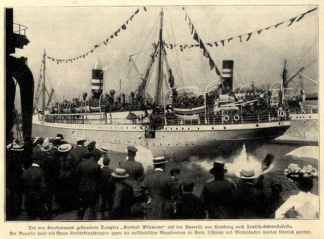
Date: 20.11.1904

30 km north of Swakopmund

The Gertrud Woermann II, a 4 600 ton passenger / cargo ship of the Woermann Line ran aground in thick fog on a reef 30 km north of Swakopmund on 20 November 1904.

She was built by Wigham Richardson at Newcastle and carried 400 soldiers, 375 horses, war material, mail and general cargo. Only one year later, her sister ship, the Gertrud Woermann I, was wrecked at Port Nolloth in South Africa. The gunboat Vineta, at that time on a visit at Swakopmund, assisted with the salvage operations, giving Swakopmund's north suburb its name. No lives were lost.

The Gertrud Woermann wreck was visible until 1912, when she disappeared under the water during a heavy storm. Only a beacon, "Gertrud Beacon", today marks the spot where she has sank. It is a popular fishing spot.

Purchase photo/4K video: portfolio1 portfolio2
Aerial photo/video service/inquiries: info@traveltonamibia.com

Wednesday, 15 December 2021

Namibia: Atlantic West Coast shipwrecks: "Fukuseki Maru" & "Gamsberg" | Кораблекрушения Намибии

Namibia: West Coast shipwrecks: "Fukuseki Maru" & "Gamsberg" | Кораблекрушения у западного побережья Намибии

Facebook groups:

NAMIBIA

SKELETON COAST NATIONAL PARK

SHIPWRECKS

30. "Fukuseki Maru"

Date: 22 March 2018

Mile 108

GPS: -21.308333, 13.695838

MVF "Fukuseki Maru No 7", Japanese tuna fishing longliner vessel ran aground near Mile 108, south of Ugab River estuary, near Durissa Bay, on 22 March 2018. The ship was en-route with tuna catch from Angola fishing grounds to Walvis Bay. It grounded on coastal rocks, crew evacuated. Navigational error was the cause of this accident.

IMO 9141223, Call sign JEKB, GT 577, built 1996, flag Japan.

Present wreck's location GPS coordinates: -21.308333, 13.695838.

31. "Gamsberg"

Date: 02 June 1981

Sandwich Harbour

Purchase photo/4K video: portfolio1 portfolio2
Aerial photo/video service/inquiries: info@traveltonamibia.com

Saturday, 11 December 2021

Namibia: Atlantic West Coast shipwrecks: "Forester" & "Frotamerica" | Кораблекрушения Намибии

Namibia: West Coast shipwrecks: "Forester" & "Frotamerica" | Кораблекрушения у западного побережья Намибии

Facebook groups:

NAMIBIA

SKELETON COAST NATIONAL PARK

SHIPWRECKS

28. "Forester"

Date: February 1897

Cape Cross

The sailing vessel "Forester" was grounded at Cape Cross in February 1897.

29. "Frotamerica"

Date: 25.03.2013

Near Anichab Rocks

The Brazilian 35 000 tons bulk cargo Frotamerica, built in 1979 by Estaleiro Ilha, on tow by MV SKUA to the scrapers, lost her tow and was wrecked near Anichab Rocks on 25 March 2013, no casualties reported.

The wreckage and oil pollution present a threat to wildlife along the coast.

Aerial photo/video service/inquiries: info@traveltonamibia.com

Tuesday, 30 November 2021

Namibia: Atlantic West Coast shipwrecks: "Erycina" & "Flora" | Кораблекрушения Намибии

Namibia: West Coast shipwrecks: "Erycina" & "Flora" | Кораблекрушения у западного побережья Намибии

Facebook groups:

NAMIBIA

SKELETON COAST NATIONAL PARK

SHIPWRECKS

26. "Erycina"

Date: 04.09.1896

Cape Cross

In 1896, the "Erycina", a sailing Norwegian bark vessel belonging to the Damaraland Guano Company sank while it was offloading coal and supplies and loading guano destined for the U.K. when strong winds blew her ashore. Additional pumps were supplied at Cape Cross, but after two days it was found that she could not be kept afloat. It was finally decided to beach her. "Erycina"'s crew was taken back to Europe by the Woermann Liner, Lothar Bohlen. Over the years many wooden parts of this ship were washed ashore in the bay north of Cape Cross. There are no recognisable traces of "Erycina" today.

27. "Flora"

Date: 31.03.1859

South of Walvis Bay

Purchase photo/4K video: portfolio1 portfolio2
Aerial photo/video service/inquiries: info@traveltonamibia.com

Monday, 29 November 2021

Namibia: Atlantic West Coast shipwrecks: "Eduard Bohlen" & "Eliza" | Кораблекрушения Намибии

Namibia: West Coast shipwrecks: "Eduard Bohlen" & "Eliza" | Кораблекрушения у западного побережья Намибии

Facebook groups:

NAMIBIA

SKELETON COAST NATIONAL PARK

SHIPWRECKS

24. "Eduard Bohlen"

Date: 05.09.1909

Conception Bay

"Eduard Bohlen": 2,272 ton/95 m long, single screw, speed 10.5 knots, German passenger / cargo ship (Woermann Line). Passenger accommodation: 1st Class: 32, 2nd Class: 14. Completed in January 1891 by Blohm & Voss, Hamburg (Yard No.75) for Die Africanische Dampschiffs AG (managed by Woermann Line), Hamburg and used on the Hamburg - West Africa route. 1895 sold to Cie. Maritime Belge du Congo, Antwerpen. "Eduard Bohlen" was repurchased by Woermann Line, Hamburg in 1898.

It was en-route from Swakopmund to Table Bay and ran aground at Conception Bay on 5 September 1909 in thick fog when it was due to offload equipment for the diamond workers near Conception Bay on her voyage from Swakopmund to Table Bay. After offloading of some cargo and equipment aboard the Eduard Bohlen marine vessel Otavi attempted to tow the Eduard Bohlen from the sandbank. Unfortunately the attempt failed, 30 passengers disembarked and were transported to Swakopmund.

Within next ten days, according to reports, so much sand settled around the Eduard Bohlen that it was possible to walk from the beach to the stranded ship at low tide. It is 800 m inland now and partially buried under the desert sand.

25. "Eliza"

Date: 1840s

Ichaboe Island

Purchase photo/4K video: portfolio1 portfolio2
Aerial photo/video service/inquiries: info@traveltonamibia.com

Sunday, 28 November 2021

Namibia: West Coast shipwrecks: "Eagle" & "Ebbtide" | Кораблекрушения Намибии

Namibia: West Coast shipwrecks: "Eagle" & "Ebbtide" | Кораблекрушения у западного побережья Намибии

Facebook groups:

NAMIBIA

SKELETON COAST NATIONAL PARK

SHIPWRECKS

23. "Eagle"

Date: 26.05.1861

South of Sandwich Harbour

23.1. "Ebbtide"

Date: 1969

Pelican Point, Walvis Bay

"Ebbtide"?: there is no other visible wreck at Pelican Point:


This motor powered fishing vessel wrecked at Pelican Point.

Monday, 5 July 2021

Namibia: West Coast shipwrecks: "Eagle" & "Ebbtide" | Кораблекрушения Намибии

Namibia: West Coast shipwrecks: "Eagle" & "Ebbtide" | Кораблекрушения у западного побережья Намибии

Facebook groups:

NAMIBIA

SKELETON COAST NATIONAL PARK

SHIPWRECKS

23. "Eagle"

Date: 26.05.1861

South of Sandwich Harbour

24. "Ebbtide"

Date: 1969

This motor powered fishing vessel wrecked at Pelican Point.

Purchase photo/4K video: portfolio1 portfolio2
Aerial photo/video service/inquiries: info@traveltonamibia.com

Wednesday, 24 March 2021

Namibia: West Coast shipwrecks: "Catherina D" & "Clara and Florence" | Кораблекрушения Намибии

Namibia: West Coast shipwrecks: "Catherina D" & "Clara and Florence" | Кораблекрушения у западного побережья Намибии

Facebook groups:

NAMIBIA

SKELETON COAST NATIONAL PARK

SHIPWRECKS

10.1. "Catherina D"

Date: 1887

Hottentot Point

This sailing barque foundered offshore, west of Hottentot Point.

14.1. "Clara and Florence"

Date: 1873

Ichaboe Island

The vessel was lost north of Hottentot Bay near Ichaboe Island.

Purchase photo/4K video: portfolio1 portfolio2
Aerial photo/video service/inquiries: info@traveltonamibia.com

Sunday, 11 October 2020

Namibia: West Coast shipwrecks: abandoned oil rig & American Whaler | Кораблекрушения Намибии

Namibia: West Coast shipwrecks: abandoned oil rig & American Whaler | Кораблекрушения Намибии

Facebook:

NAMIBIA

SKELETON COAST NATIONAL PARK

TRAVEL NAMIBIA

SHIPWRECKS

1. Abandoned oil rig

Location: Skeleton Coast, near Toscanini

GPS: -20.890122, 13.447250

YouYube video:

Cease of operations date is not known. An abandoned rusted oil drilling rig, located near Toscanini, was operational in the late 60's and early 70's. Rig is equipped with main power unit, V16 Caterpillar engine and was installed by brave local entrepreneurs long before the Skeleton Coast National Park was proclaimed. Today, rusty structure provides a nesting area for birds during breeding season.

2. American Whaler

When: 1800’s

Location: Omaruru River mouth

Some old sail ship ribs and beams were visible above the high water mark at the Omaruru River mouth. Visitors like Hentie van der Merwe and Sergeant Ross of the Omaruru police used to cut their bait on one of the large beams. In later years some of these wooden sail ship beams might have been used as building material for some of the first holiday houses erected at Henties Bay, or carried away by one of the salt companies who operated further north.

Excerpt from Dr. Vedder "Das alte Sudwestafrika", 1981 book:

“Herero chief Hembapu returned along the coast towards the Omaruru River after a raid on some Nama further south. At the river mouth they came upon a shipwreck and two naked white men – white people they had never seen before. They gave them Omaire. The one man died shortly afterwards. They slaughtered an ox in order to leave some meat for the other survivor. The Hereros then commenced trekking further inland along the Omaruru River.” Unfortunately, no date of that particular incident is known.

Purchase photo/4K video: portfolio1 portfolio2
Aerial photo/video service/inquiries: info@traveltonamibia.com