Showing posts with label Spencer Bay. Show all posts

Sunday, 21 April 2024

South Africa: Maria & Iolite shipwrecks

SAHRA Maritime and Underwater Cultural Heritage

Otavi shipwreck in Namibia

March 21:

“This day in our shipwreck and aeronautical wreck history”

1862: Maria, this wooden sailing vessel (cutter-rigged) wrecked on the sand bar at Hondeklip Bay with the loss of one life.

1969: Iolite, this South African fishing vessel was scuttled on this day in False Bay in the Western Cape.

Purchase photo/4K video: portfolio1 portfolio2
Aerial photo/video service/inquiries: info@traveltonamibia.com
Telegram: ExploringNamibia

Sunday, 4 February 2024

Namibia: Diamond Area 2 - Historical information

Diamond Area 2 in Namibia

Historical information

Remains of a one-man box at Grillenberger

The discovery of diamonds in 1908 around Kolmanskuppe resulted in an uncontrollable diamond rush forcing the Government to establish the “Sperrgebiet” between 26-degree (Gibraltar) and the southern border stretching 100 km inland. Prospectors were forced to turn northwards beyond the Sperrgebiet.

This resulted in the discovery of diamonds at Spencer Bay in December 1908 and between Meob and the Conception Bay area (Diamond area no 2). This resulted in a total of 5000 diamond claims being registered in 1909 and hopeful prospectors tried their luck at Saddle Hill and Spencer Bay and via Swakopmund and Sandwich Harbour southwards towards Meob Bay.

However, the small yields of diamonds from these claims resulted in only a few prospectors being successful in the long term. Transporting of supplies and mine equipment was effected mainly from Swakopmund by ship and the cutter Viking via Sandwich Harbour, Conception Bay and Meob Bay. Various shipping casualties occurred, such as when the Eduard Bohlen intended to offload mining equipment, was consequently lost at Conception Bay (1909). In the area between Conception Bay and Meob Bay the mining settlements of Holsatia, Charlottenfelder and Grillenberger was established and no form of engine-driven transport was available during the first 15 years. One example of an ox-wagon fitted with special wide iron bands to make transportation in sandy areas possible can be seen north off Grillenberger. 

This wagon and surfboats at Meob Bay are examples of pre-World War I historical relicts depicting the immense difficult pioneering days in those inhospitable desert conditions. During 1912/1913 a light railway from Conception Bay to Conception Water and an 80-kilometer pipeline linking the settlements were constructed. It is not totally clear as how many pre-fabricated buildings were erected at the various settlements and only the foundations of some of these are still visible today. In November 1914 all people in this area were requested to stop operations and to proceed to Swakopmund up country. This order came as a result of an expected invasion of Allied troops. During 1920 activities recommenced in this area and only four companies operated in this area until De Beers purchased one concession area after another in 1929. From old mining records it is clear that the average diamond found in this area was much smaller than those found south of Lüderitzbucht.

Operators made use of hand-operated movable sieve jigs, and were largely dependent on an Ovambo labour force. Namaqua Diamonds for instance employed between 500 and 600 Ovambos under contract. They were distributed in gangs of 50 over the extend of the mining area. Some of the sieve jigs are today still visible at the old mining settlements. In 1932 the price of diamonds dropped considerably and almost all known diamondiferous ground has been worked over at least once. The small diamonds left in the tailings of earlier workers made productions uneconomic. After World War II a company Industrial Diamonds of South Africa (1945) Ltd. conducted extensive prospecting in the Meob area in which no diamonds were recovered and CDM also abandoned Meob Bay in the early 60’s. Today only some remnants of the activities are visible and are deteriorating at an alarming rate. There are a limited quantity of hand-operated mining equipment left, two surf boats at Meob and ox-wagon north of Grillenberger giving some in-sight into the hardships endured by indigenous Namibians and early settlers to Namibia.

Saddle Hill became well known in Namibian diamond operations through the efforts of the remarkable Mose Kahan. The unsinkable Mose was born in Königsberg, Prussia and after immigrating to South Africa, he became involved in prospecting and mining. His application for a concession in Diamond area no 2 was successful and he named his claims Saddle Hill Ophir and Atlantis. To reach his claims with food and mining supplies, Kahan had to make his way through shifting dunes with transport available in those years, which was indeed a hazardous undertaking.

After World War II Kahan bought some Ford “stompneus” trucks from surplus war stock and fitted them with Dakota DC3 aircraft tyres. With these low-pressure aircraft tyres he was able to bring supplies and equipment to Saddle Hill. However one of these trucks, nick named Suzie as well as a Bulldozer, pulling trailers with supplies and equipment close to the Uri Haugab Mountains unfortunately had to be abandoned in the dunes, today still awaiting the return of a repair crew.

Purchase photo/4K video: portfolio1 portfolio2
Aerial photo/video service/inquiries: info@traveltonamibia.com
Telegram: ExploringNamibia

Saturday, 3 February 2024

Namibia: Fascinating Diamond History

Fascinating Diamond History in Namibia

The prospects for diamond mining in the area of Meob Bay started during the diamond rush of 1908 to 1914.

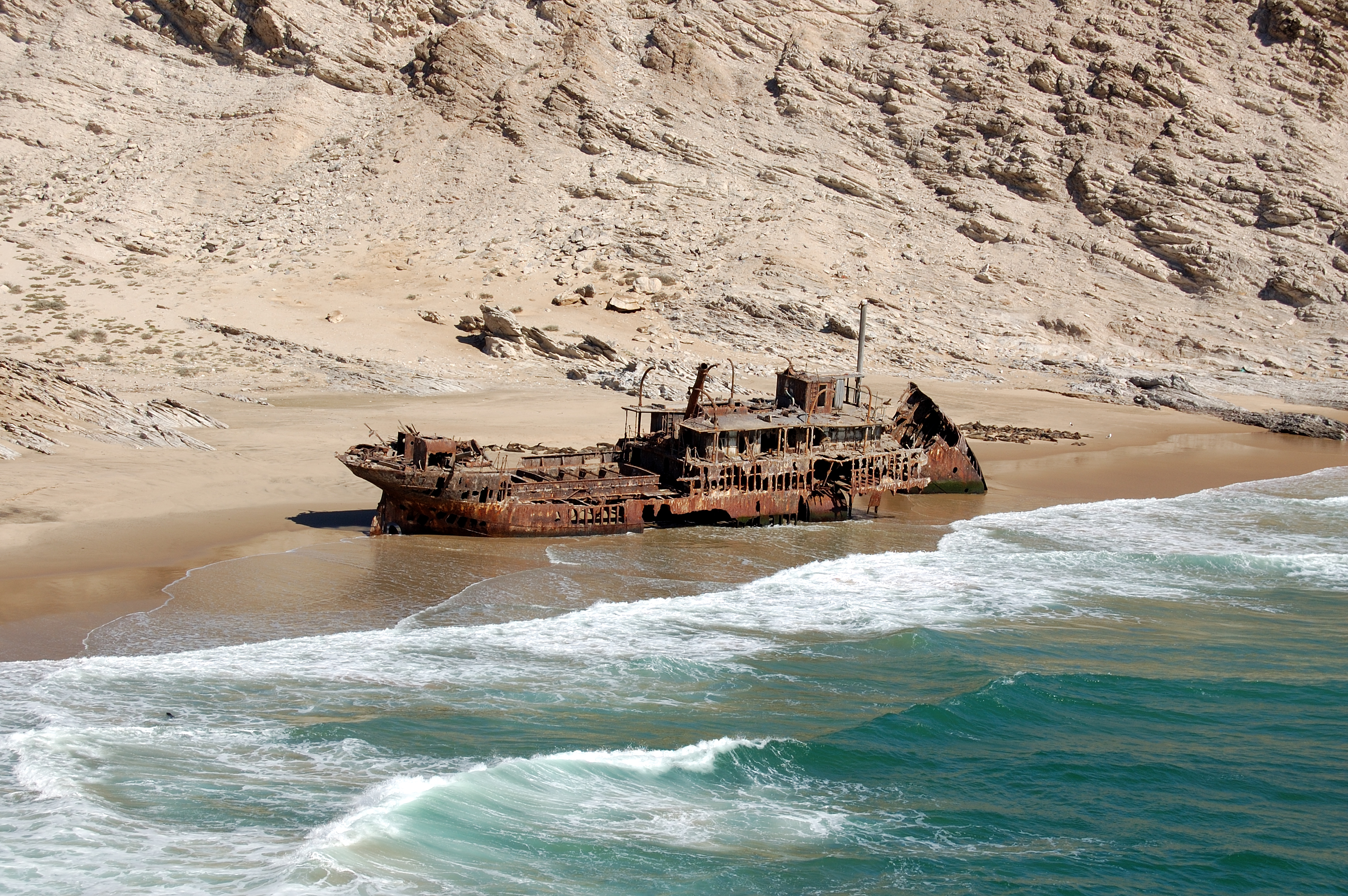
The coastline of Namibia is home to a number of archaeological sites. The area of Meob Bay, which is about 173 km from Walvis Bay, also forms part of the early days of the diamond mining area.

Only operators who are concession holders are allowed to travel in these restricted areas.

This area between Meob Bay and Conception Bay (104 km from Walvis Bay) area is Diamond area no. 2.

Meob Bay was used as a harbour to offload mining equipment and personnel during the diamond rush from 1908 to 1914. By 1928 various infrastructure improvements were made, a bakery was in operation by then, providing settlements with fresh bread on a weekly basis with an introduced mule express.

The only remaining hut, today at Meob Bay, served as an office and accommodation to the then transport manager of the Namaqua Diamond Company.

DIAMOND MINING

The official story of Namibia’s diamond history starts in April 1908, when young railway worker Zacharias Lewala picked up a large shiny diamond while on duty during the railway construction between Lüderitz and Kolmanskuppe. Little did he know that this ordinary act would set off a chain of events so large, it would change the course of history.

An avalanche of fortune hunters, whose eyes sparkled in awe of the world’s purest, most precious diamonds, descended upon this desert land.

This resulted in an uncontrollable diamond rush, forcing the secretary of the colonial administration, Dr. Bernhard Dernbug, to proclaim a ‘Sperrgebiet’, between 26 degrees south latitude (Gibraltar/ Northern Rocks, 75 km north of Lüderitz) and the Orange River stretching 100 km inland.

This southern area covered 26 000 km². Existing claims were honoured, but mining rights for the rest of the land were given to the Deutsche Kolonialgesellschaft für Südwestafrika to control prospecting.

Prospectors then started to turn northwards and this resulted in the discovery of diamonds at Spencer Bay in December 1908 as well as between Meob Bay and Conception Bay area.

Transporting of supplies and mining equipment was mainly from Swakopmund by ship and the cutter vessels Viking via Sandwich Harbour, Conception Bay and Meob Bay. The mining settlements of Holstatia, Charlottenfelder and Grillenberger were established during the 1920s.

The biggest of the settlements, Grillenberger, was home to a large machine workshop, store, a small field hospital with 20 beds, a slaughter house, police office and post office with a switchboard for local telephone communication.

For senior employees, a hall was erected as well as storage facilities and stables. For the contract labourers, A-frame huts were erected, which can still be seen. About 12 contract labourers were housed in these A-frame huts.

North of Grillenberger, an ox wagon can be seen with special wide iron bands that made transportation possible in the sandy areas.

Also to be seen in the area is a railway line running from Conception Water to Conception Bay. The latter was used as a harbour, and at Conception Water boreholes provided fresh water to the surrounding areas. From Conception Water, a 80 km water pipeline was constructed to supply the three mining settlements with water.

In 1914, everyone in this area was requested to stop all diamond finding operations and to proceed to Swakopmund. This order came as a result of an unexpected invasion of allied troops.

During 1920, activities recommenced in this area and only four companies operated here until De Beers purchased the concession areas in 1929. From old mining records it is clear that the average diamonds found in this area were much smaller than those found at Lüderitz.

The great depression, which led to the crash of the New York stock exchange in October 1929, negatively affected the sales of diamonds from these diamond fields.

Consequently, Namaqua Diamonds ceased operations on 28 January 1931 and went into liquidation. Most of the concessions were then bought by Consolidated Diamond Mines (CDM) of South West Africa. Since then the South West Africa administration closed these diamond fields for prospecting, and all 389 workers and European employees had to leave these fields within hours, leaving everything behind.

After the second World War a company Industrial Diamonds of South Africa (1945) did extensive prospecting in the area around Meob, but found no diamond and CDM abandoned Meob in the early 1960s.

RECOVERY METHODS

During the first weeks of the diamond rush, diamonds were picked up by hand from the surface of the desert. People crawled on the ground with jam tins to put in the diamonds.

To speed up the process, sieves were used to separate the fine sand from the larger grains, which contained the diamonds. Charlie Bannau, introduced a more sophisticated method, where he submerged the sieve with the coarser gravel in a trough filled with sea water, then rotated it. By doing this the diamonds moved to the centre of the sieve. He then placed the sieve upside down on the back of an empty beer crate from where the diamonds could be picked up. However, the problem was the use of too much water in the desert.

Shortly after, the Trommel sieves were introduced. They were hand operated and larger amounts of sediments could be sieved. Subsequent to the sieving, the diamond bearing gravel was hand or gravitated in smaller round sieves.

Today, only remnants of these activities are visible and are deteriorating at an alarming rate. These settlements give a rare insight into the harsh desert environment and the hardships endured by the indigenous people and early settlers of Namibia.

Purchase photo/4K video: portfolio1 portfolio2
Aerial photo/video service/inquiries: info@traveltonamibia.com
Telegram: ExploringNamibia

Wednesday, 31 January 2024

Namibia: The Northern Diamond Fields

The Northern Diamond Fields

When in October 1908 prohibitive restrictions were placed on the pegging of claims south of the 26° latitude in the southern diamond fields (Kolmanskuppe, Bogenfels, Elizabeth Bay) many a prospector left the area for the less popular northern diamond fields (Spencer Bay, Saddle Hill, Oyster Cliffs, Meob Bay, Conception Bay), in the hope of some good finds.

In 1909 after about 5,000 claims had been occupied, it was found that these fields were much poorer than those in the south as well as having a lot more obstacles standing in the way of their development, including the vast distances and transportation difficulties. Nevertheless, there was no shortage of optimistic prospectors as they came from all walks of life wanting to try their luck at diamond mining and surely many dreamed of overnight riches.

Today when entering this remote area, it is not difficult to imagine the hardship man, beast and machine had to endure. Harsh desert conditions, with the cold, fog and the ever-blowing cold southerly winds.  The area is difficult to describe as there is an abundance and vastness of nothingness and yet so much beauty.

Hats off to those early pioneers and migrant workers who entered into this way of life making a tremendous contribution to the economic success of the diamond industry.


Purchase photo/4K video: portfolio1 portfolio2
Aerial photo/video service/inquiries: info@traveltonamibia.com
Telegram: ExploringNamibia

Sunday, 16 October 2022

Namibia: West Coast shipwrecks: "Orca" & "Otavi" | Кораблекрушения у западного побережья Намибии

Namibia: West Coast shipwrecks: "Orca" & "Otavi" | Кораблекрушения у западного побережья Намибии

Facebook:

NAMIBIA

SKELETON COAST NATIONAL PARK

SHIPWRECKS

70.1. "Orca"

Date: 1978

Palgrave Point

This motor powered fishing vessel capsized near the Uniab River, north of the Palgrave Point area.

71. "Otavi"

Date: 1945

Spencer Bay

A steamer ran aground in the forties whilst loading guano from Mercury Island. Ran aground in Spencer Bay in 1945. "Otavi" wreck was stranded at Spencer Bay's beach in a small bay.

This wreck can only be reached by foot or by sea. This resulted in the wreck being virtually preserved untouched.

Purchase photo/4K video: portfolio1 portfolio2
Aerial photo/video service/inquiries: info@traveltonamibia.com
Telegram: ExploringNamibia

Saturday, 21 November 2020

Namibia: West Coast shipwrecks: "Anne Mondell" & "Arcona" | Кораблекрушения Намибии

Namibia: West Coast shipwrecks: "Anne Mondell" & "Arcona" | Кораблекрушения Намибии

Facebook:

NAMIBIA

SKELETON COAST NATIONAL PARK

TRAVEL NAMIBIA

SHIPWRECKS

3. "Anne Mondell" wreck

No image available

Date1840s

LocationIchaboe Island

4. "Arkona" wreck


Dateunknown

Location
Namib-Naukluft National Park, north of Spencer Bay

Remains of "Arkona" shipwreck is located a couple of kilometres north of the "Otavi" wreck. The shipwreck is hardly visible.

Purchase photo/4K video: portfolio1 portfolio2
Aerial photo/video service/inquiries: info@traveltonamibia.com